- KDDI HOME
- Corporate Information
- News Releases
- 2019
- Strategic partnership with Sturfee, owns unique VPS technology: power cameras with 3D location recognition anywhere in city using satellite imagery
Strategic partnership with Sturfee, owns unique VPS technology: power cameras with 3D location recognition anywhere in city using satellite imagery
―Building City-scale 3D Location Fingerprint Maps for the 5G Era―
- KDDI CORPORATION
June 24,2019
We are pleased to announce that KDDI has entered into a strategic partnership with Sturfee Inc. (Headquartered in California, USA, CEO: Anil Cheriyadat, Sturfee) to jointly plan and develop services that utilize VPS technology, with the aim of creating a new communication scene in the 5G era and addressing spatial computing.
VPS (Visual Positioning Service) is deemed an evolution of the conventional Global Positioning System (Global Positioning System), a technology that matches 3D maps (3D Mesh), which are digital twins in the real world, with images taken through a camera installed in a smartphone or smart glass to identify highly accurate position information, including direction and orientation. Combined with AR (augmented reality), which also utilizes the camera functions of smartphones and smart glasses, it is expected to create a variety of new experiences, including digital signage and navigation linked to location information, as well as advertising, entertainment, art and education.
Sturfee has technology that can generate 3D location fingerprint maps for VPS from satellite imagery that can provide smartphones and wearable visual intelligence to recognize 3D surroundings anywhere in the city instantly. Compared to conventional method, for example 3D model generation using images taken with a smartphone or camera, it can make AR more seamless and more efficient for the entire city and space.
As part of this strategic partnership, KDDI will combine the VPS platform developed by Sturfee with KDDI's own content management server to offer VPS services to prospective customers and support their domestic usage.
Sturfee's technology will be on display at KDDI's corporate event "![]() KDDI 5G SUMMIT 2019" on June 27, 2019.
KDDI 5G SUMMIT 2019" on June 27, 2019.
Anil Cheriyadat, CEO of Sturfee, says:.
"Smartphones and wearables capable of recognizing and reacting to your surroundings using computer vision and AI will power the next era of communication in XR. VPS service could be a killer 5G service for smartphones and the anticipated large market for smart glasses in Japan. It is a great honor for us to be involved in making next-generation mobile computing happen in this field together with KDDI, one of the world's largest telecommunications companies."
As KDDI works to integrate telecommunications with life design, we will fulfill our role as a company that provides excitement, creating new kinds of communication through XR applications in the 5G era to generate new experiential value.
1. Strategic Partnership Overview
- Promotion of 3D location fingerprint map generation, joint planning and development for VPS in Japan
- Promotion of demonstration tests with partner companies in Japan
2. Sturfee Technology Features
-
- (1)
-
Precise, and extensive 3D location fingerprint maps
Sturfee can create City-scale 3D models, digital twins of the real world, from satellite imagery. A place where buildings exist, and where satellite photographs can be obtained, it is possible to make Sturfee VPS area.AI-powered 3D Location Recognition
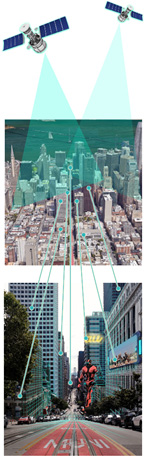
High esolution Satellite View
Satellite imaging allows us to analyze and organize ground data (trees, roads, and building geometries) from the sky and build a 3D mesh of the city.City-scale Visual Fingerprint Map
Every single location is converted into a visual fingerprint using the ground data we analyzed from satellite imagery, transforming the city into a fingerprint map.Computer Vision 3D Recognition
Our proprietary computer vision algorithms instantly extract visual fingerprint map to determine the user's exact location and project e 3D mesh for AR usage.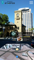
(Store information in the city overlaid on the building)
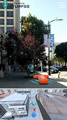
(Show route to destination on road)
-
- (2)
-
Realization of Marker-less AR outdoors
Instead of using the "QR Code" (trade mark of Denso wave, Ltd.), which has been used as a location marker in conventional AR services, you can use the landscape of the city itself, including buildings you normally see, to identify the location.For example, when you get out of a subway station and go up to the ground, you can quickly identify the exact position and the direction to which you are facing by simply holding up your smartphone or smart glass camera. Compared with the existing method of locating using only GPS functions, you can expect to be less likely to get lost.
Moreover, since the surrounding buildings and roads can be grasped as three-dimensional objects, not only the location and direction can be determined, but also the city itself can be used as a 3D space, and by combining with AR technology, it becomes possible to offer more advanced games (Use absolute position information instead of relative one) with the city as the stage.
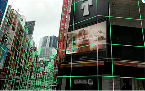
Recognize surrounding buildings and roads as 3D meshes
(image photo for illustration purposes only)